Sab ko sms karke samjao please don't listen
rahat fatah's new song "aj din charhiya" in "LOVE AJ KAL" Is singer ne
is song mai ALLAH ke khilaf bakwas ki hai ke "maanga jo mera hai, jata
kya tera hai, mein ne kaunsi tujh se jannat manli, kaisa khuda hai, tu
bas naam ka hai, jo rabba teri itni si bhi na chali " Nauzbillah Is msg
ko itna felao. jitna LA ILAHA ILALLAH pey imaan hai. Taaki is singer ke
song band ho sakey... plzzzz forward 2 all muslims .......
if you are a true muslims then stop that song ...........
Interstate System

The United States is covered with a convenient system of U.S. and Interstate highways. Interstates are always freeways (limited access; no grade crossings), while U.S. Highways may be freeways on some sections and not on others. These roads network between major (and minor) population centers, and can make it easy to cover long distances – or get to the other side of a large city – quickly. Primary Interstates have one- or two-digit numbers, with odd ones running north-south (e.g. I-5) and even ones running east-west (e.g. I-80). Three-digit interstate numbers designate shorter, secondary freeways. An odd first digit signifies a "spur" into or away from a city; an even first digit signifies a "loop" around a large city. The second two digits remain the same as the primary Interstate that travels nearby. The U.S. Highways are generally older routes that lead through town centers. In many cases, Interstates were constructed roughly parallel to U.S. Highways to expedite traffic that wishes to bypass the city.
Speed limits on the interstate highways can vary from state to state, as setting the speed limit is up to each individual state. For example, Interstate 70 from east to west is 65 miles per hour in Pennsylvania and Ohio, 70 miles per hour in Indiana, 65 miles per hour in Illinois, 70 miles per hour in Missouri and Kansas, and up to 75 miles per hour in Colorado and Utah.
The vast majority of interstates do not charge tolls, but those that do are also known as turnpikes. Tolls are also frequently levied for crossing notably large bridges or tunnels.
Get in
The United States has exceptionally onerous and complicated visa requirements. Read up carefully before your visit, especially if you need to apply for a visa, and consult the official United States Visas site for current information.
The US territories of Guam and the Northern Mariana Islands have slightly looser entry requirements from the rest of the country; see those pages for details.
Visa-free entry

Citizens of the 35 countries within the Visa Waiver Program , as well as Canadians, Mexicans living on the border (holding a Border Crossing Card) and Bermudans (with British Overseas Territories passports) do not require advance visas for entry into the United States. In the case of Canadians and Bermudans, the entry period is normally for six months maximum. However, since 2009, even visa-free travelers must now apply for Electronic System for Travel Authorization (ESTA) approval online before their flight, preferably 72 hours before travel. ESTA approval is free and, once granted, is valid for two years (or until your passport expires).
Travel under the Visa Waiver Program is limited to 90 days for tourism or business purposes only; neither employment nor journalism is permitted with a Visa Waiver. The 90-day limit may not be extended nor will travel to Canada, Mexico, or the Caribbean reset the 90-day limit.
As of December 31, 2008, the countries under the Visa Waiver Program are Andorra, Austria, Australia, Belgium, Brunei, Czech Republic, Denmark, Estonia, Finland, France, Germany, Hungary, Iceland, Ireland, Italy, Japan, South Korea, Latvia, Liechtenstein, Lithuania, Luxembourg, Malta, Monaco, the Netherlands, New Zealand, Norway, Portugal, San Marino, Singapore, Slovakia, Slovenia, Spain, Sweden, Switzerland, United Kingdom.
Citizens of the Federated States of Micronesia, the Marshall Islands, and Palau may enter, reside, study, and work in the US indefinitely with only a valid passport.
Visa Waiver Program Requirements
Passports issued after October 26, 2005 need digital photographs embedded on them, and passports issued after October 26, 2006 must be biometric passports, which have a chip embedded with the user's information. Some countries, e.g. France, did not have biometric passports available at that date, meaning that citizens from these countries with newer passports but not biometric passport have to obtain a tourist visa, which can be a cumbersome, costly and time-consuming process. If you have a non e-passport issued after October 26, 2006 and you are from a Visa Waiver country, try having your government exchange it for an biometric passport, explaining that you wish to travel to the U.S.
Entry under the VWP from air or sea also requires entry via an approved carrier. It is a somewhat safe assumption that most major airlines and sea carriers are approved, but make certain that the carrier is approved to carry Visa Waiver visitors. Notably, however, this means that flying private aircraft or chartering a vessel to the United States requires a full visa.
Travelers must also have a return/onward ticket out of the United States. If the return/onward ticket terminates in Canada, Mexico, Bermuda, or any Caribbean island, the traveler must be a legal resident of that country/territory. If traveling by land, there is a $7 fee when crossing the border.
The I-94W form (see below) has a checklist of conditions that may deny visa waivers. Most of these are not a problem for most visitors ("Have you ever been or are you now involved in espionage, sabotage, terrorist activities, genocide?"), but the important one is that if you have ever been denied a US visa for any reason or overstayed on a previous visa, you will be denied entry. Having a criminal history with convictions for "crimes of moral turpitude", controlled substance (drug) offenses, or jail terms of more than five years total are also disqualifying factors.
Obtaining a visa
For the rest of the world, the visa application fee is US$131 (as of 1 January 2008; not refundable). The Immigration and Nationality Act states that all persons requesting entry into the United States as non-immigrants are presumed to be immigrants until they overcome that presumption by showing evidence of "binding ties" to your home country as well as sufficient proof that your visit will be temporary. When the US rejects visa applications, it is usually because the applicant does not have enough binding ties to his own country to convince the consular officer that he or she is not planning to be an immigrant. Face-to-face interviews (where the official needs to be convinced that you are not a "potential immigrant") at the nearest U.S. embassy or consulate are required for many nationalities, and waits for interview slots and visa processing can add up to several months.
Depending on your nationality and the category of visa you are requesting, you may need to pay an additional fee (ranging from US$7 to US$200) only if the visa is issued. This is called a reciprocity fee, and is charged by the US to match the fees charged by other countries on US citizens.
Do not assume anything. Check on documentation requirements with the United States State Department or with the United States consulate nearest you. If coming to the country with a car, be sure to have documents showing car insurance, rental agreements, driver's license, etc., before trying to enter the U.S.

Arriving in the United States
Before arrival, you will receive either a white I-94 (if entering with a visa) or green I-94W (if entering on a visa waiver) form to complete.
If you are not a citizen or resident of the United States, you will go through a short interview at immigration, where the official will try to determine if the purpose of your visit is valid. Of most concern to immigration officials is that you have the funds to support yourself, and that you do not intend to work. Be prepared to show proof. If you are on a business visit, have an invitation letter from the company you are visiting, or the registration details of the conference you are attending. If you are a tourist, you may need to demonstrate you have funds available to you. In both cases proof of onward travel may be required. Usually, the determination of admissibility is made in a minute or less, however if there are any doubts, you may be referred to further questioning in a more private area. At this stage they will likely search your possessions, and may read any documentation, letters or diaries in your possession. Once they decide to let you in, you are fingerprinted and a digital photograph is taken. As in most countries, assume that customs official are humorless about any kind of security threat; even the most flippant joke implying that you pose a threat can result in lengthy interrogation.
For non-residents, your entry forms will need to state the street address of the location where you will be staying; this should be arranged in advance. The name of your hotel, hostel, university, etc. may not be sufficient; you must provide the street name and number. If staying in multiple locations, provide the address where you will be spending the first night of your stay. If it is a hotel, have a reservation under your name. If it is a private address, make sure that the people there know that they are expecting you that day, as if your plans are doubted border control officials may phone them and ask them for the name of the guest they are expecting.
For technical and scientific fields of work or study, processing non-immigrant visa application can take up to 70 days, as it can require 8 weeks for receiving an approval from authorities in Washington. This especially applies to military and dual-purpose fields which mentioned in a so-called technical alert list (a copy can be found at [6]).
[edit] At customs
Travelers should avoid bringing meat or raw fruit or vegetables into the U.S., but may bring cooked nonmeats, such as bread. See APHIS [7] for details. The U.S. Customs process is straightforward. Most articles that are prohibited or restricted in any other country are prohibited or restricted in the USA. The only rule that is unique to America is that it is generally prohibited to bring in goods made in countries on which the U.S. has imposed economic sanctions, e.g., Cuba, Iran, North Korea, and Myanmar (Burma). Besides their personal effects which will go home with them, visitors are allowed to import $200 of merchandise duty free, including 1 liter of alcohol (21 and older only) and 1 carton of cigarettes. If you are bringing in more than US$10,000 or its equivalent, you must declare it on your customs form and you will be given a special form to fill out. At immigration, the officer usually puts some sort of a tick mark on your customs declaration form to alert the customs officer of any need to search you or your luggage. After you are admitted into the U.S. and you retrieve your bags, you will proceed to the secondary inspection area (customs checkpoint). Hand your customs declaration to the officer. Most of the time, the officer will point you to the exit and that will be it. The officer may ask you some routine questions and then let you go. The officer may refer you to the x-ray to have your bags inspected, or may refer you for a manual search of your bags. Customs has the right to search your person and your bags, but any search more intrusive than a bag search is rare, and is usually indicated only if some sort of probable cause has been established through questioning or during the bag search to suggest suspicious activity.
[edit] Leaving the United States
There are additional pilot security measures dubbed US-VISIT [8] requiring you to leave your fingerprint and photograph at a kiosk even while leaving. This is applicable at a majority of land, sea, and air entry ports. Check the list, as most of the ports of entry are covered.
Airline or border staff will take the I-94(W) card stapled in your passport from you on departure, but you should check and insist on it. If you leave the country with it still in your possession, contact U.S. officials about how to return it and update your departure records to avoid entry hassles in the future. US Customs and Border Protection has information [9] about what to do if your slip is not collected. You should retain this card if you are traveling by land to Mexico or Canada and you will return to the U.S. within your allowed stay.
By plane

Most visitors from outside Canada and Mexico arrive in the United States by plane. While many medium sized inland cities have an international airport, there are limited flights to most of these and most travelers find themselves entering the U.S. at one of the major entry points along the coasts:
- From the east New York City, Chicago, Philadelphia, Atlanta, Boston, Washington, D.C., and Miami are the primary entry points from Europe and other transatlantic points of departure. All the major east coast airports have service from a few key European cities.
- From the west Los Angeles, San Francisco, Honolulu are the primary points of entry from Asia and other transpacific points of departure. Seattle has some international flights, and Portland (Oregon) has a daily flight to Tokyo. Of course, if you arrive in Honolulu, you must take another flight to get to the mainland. Foreign airlines are not allowed to transport passengers to/from Hawaii or Alaska and the other 48 states (except for refueling and in-transit). If you are flying into the west coast to transit to another destination, San Franscisco airport has a free frequent skytrain linking terminals and short security queues, compared to Los Angeles which will see you exposed to the elements catching a shuttle bus or walking between terminals.
- From the south Miami, Florida is the primary entry point from Latin America, primarily South America. Also, Dallas, Houston, Atlanta, and Charlotte are major international waypoints. From Mexico, most major U.S. airports have non-stop service.
- From the other side of the world New Delhi, India has non-stop service to Chicago and Newark (New Jersey). From Pakistan, Saudi Arabia, Uzbekistan and United Arab Emirates you can also fly to New York (JFK). Qatar, and Saudi Arabian fly to Washington, DC, and South African Airways goes to New York (JFK) and Washington, DC (Dulles).
Note that the United States requires entry formalities even for international transit, and the current state of international affairs means that this is not going to change anytime soon. You must have a valid visa to enter the United States if required by your citizenship, even if you are immediately continuing on a flight to a different country. If your citizenship requires a visa to enter the U.S., avoid transiting through the U.S. unless you want to spend time and money to obtain a C-1 transit visa. Further, when booking flights to the U.S. note that you will be required to clear customs and immigration at your first U.S. stop, not at your final destination, even if you have an onward flight. Allow at least 2 hours of stop-over (ideally more than 3) at your first U.S. stop.
United States

The United States has over 10,000 cities, towns, and villages. The following is a list of nine of the most notable. Other cities can be found in their corresponding regions.
- Washington, D.C. - The national capital, and a multi-cultural community.
- Boston - The capital of Massachusetts, best known for its colonial history, its passion for sports, and university students.
- Chicago - The "Windy City", heart of the Midwest, transportation hub of the nation, notable for its massive skyscrapers and other architectural gems.
- Los Angeles - The United States' 2nd largest city; home of the film industry, palm-fringed neighborhoods, mountains, beaches, freeways, pollution, and sunshine.
- Miami - Miami attracts sun-seeking northerners and strivers from Latin America and the Caribbean.
- New Orleans - "The Big Easy" is known for its quaint French Quarter and annual Mardi Gras celebration.
- New York - The United States' largest city, home of the financial services and media industries, with world-class cuisine, arts, and a diverse population.
- San Francisco - Gateway to the California coast, wine country, and Yosemite National Park.
- Seattle - Known for Microsoft and Starbucks, and has 5 distinct climates within 200 miles of the city center, including 14,000' peak Mt. Rainier, temperate rain forests, Pacific Ocean, and arid desert.
[edit] Other destinations

These are some of the largest and most famous destinations outside of major cities.
- Denali National Park, Alaska - Remote national park with North America's highest peak.
- Grand Canyon, Arizona - The world's longest and most visited canyon.
- Mesa Verde National Park, Colorado - Well-preserved Ancestral Puebloan cliff dwellings.
- Mount Rushmore, South Dakota - Iconic memorial of 4 former presidents carved into a cliff face.
- Niagara Falls, New York - Massive waterfall straddling the border with Canada.
- Great Smoky Mountains National Park, North Carolina - National park in the southern Appalachian.
- Walt Disney World, Florida - The most popular resort destination in the world
- Yellowstone National Park, Wyoming - The first national park in the US, and home of Old Faithful geyser.
- Yosemite National Park, California - Home of El Capitan and the famous Giant Sequoia trees.
See United States National Parks for a list of all national park areas.
Regions
The United States is composed of 50 states, as well as the city of Washington D.C., a federal district and the nation's capital. Below is a rough grouping of these states into regions, from the Atlantic to the Pacific:

| New England (Connecticut, Maine, Massachusetts, New Hampshire, Rhode Island, Vermont) Home to gabled churches, rustic antiques, and steeped in American history, New England offers beaches, spectacular seafood, rugged mountains, frequent winter snows, and some of the nation's oldest cities, in a territory small enough to tour (hastily) in a week. |
| Mid-Atlantic (Delaware, Maryland, New Jersey, New York, Pennsylvania) Ranging from New York in the north to Washington D.C., the Mid-Atlantic is home to some of the nation's most densely populated cities, as well as historic sites, rolling mountains, the New Jersey Pine Barrens, the Lehigh Valley, and seaside resorts like the Long Island beaches and the Jersey Shore. |
| South (Alabama, Arkansas, Georgia, Kentucky, Louisiana, Mississippi, North Carolina, South Carolina, Tennessee, Virginia, West Virginia) The South is celebrated for its hospitality, down-home cooking and its blues, jazz, rock 'n' roll, and country music traditions. This lush, largely subtropical region includes cool, verdant mountains, agricultural plantations, and vast cypress swamps. |
| Florida Northern Florida is similar to the rest of the South, but not so the resorts of Orlando, retirement communities, tropical Caribbean-influenced Miami, the Everglades swamp, and 1200 miles of sandy beaches. |
| Midwest (Illinois, Indiana, Iowa, Michigan, Minnesota, Missouri, Ohio, Wisconsin) The Midwest is home to farmland, forests, picturesque towns, industrial cities, and the Great Lakes, the largest system of freshwater lakes in the world, forming the North Coast of the U.S. |
| Texas The second biggest state in the nation, it's like a whole other country (and in fact, once was). The terrain ranges from southeastern swamplands to the cattle-ranching South Plains to the sandy beaches of South Texas to the mountains and deserts of West Texas. |
| Great Plains (North Dakota, South Dakota, Nebraska, Kansas, Oklahoma) Travel westward through these supposedly flat states, from the edge of the eastern forests through the prairies and onto the High Plains, an enormous expanse of steppes (shortgrass prairies) as desolate as in the frontier days. |
| Rocky Mountains (Colorado, Idaho, Montana, Wyoming) The spectacular snow-covered Rockies offer hiking, rafting, and excellent snow skiing as well as deserts, and some large cities. |
| Southwest (Arizona, New Mexico, Nevada, Utah) Heavily influenced by Spanish and Mexican culture, this area is home to some of the nation's most spectacular natural attractions and some flourishing artistic communities. Although mostly empty, the region's deserts have some of the nation's largest cities. |
| California Like the Southwest, California has a history under Spanish and Mexican rule and is heavily influenced by Spanish and Mexican culture. California offers world-class cities, deserts, rain forests, snowy mountains, and beautiful beaches. Northern California (around the Bay Area) and Southern California (around Los Angeles) are culturally distinct. |
| Pacific Northwest (Washington, Oregon) The pleasantly mild Pacific Northwest offers outdoor pursuits as well as cosmopolitan cities. The terrain ranges from spectacular rain forests to scenic mountains and volcanoes to beautiful coastlines to sage-covered steppes and deserts. |
| Alaska One fifth as large as the rest of the United States, Alaska reaches well into the Arctic, and features mountainous wilderness. |
| Hawaii A volcanic archipelago in the tropical Pacific, 2,300 miles south west of California (the nearest state), laid-back Hawaii is a vacation paradise. |
Politically, the U.S. is a federation of independent states each with its own rights and powers (hence the name); see list of American states for a full listing. The U.S. also administers a motley collection of non-state territories around the world, the largest of which are Puerto Rico and the U.S. Virgin Islands in the Caribbean plus American Samoa, Guam and the Northern Mariana Islands in Oceania.
Culture
Culture

Because of its size and because its citizens are descended from diverse immigrants, there is no single universal American culture. Visitors to the South will find a far different culture from those traveling to California or New York City.
[edit] Holidays
The US has a number of holidays - official and/or cultural - of which the traveller should be aware. Note that holidays observed on Mondays are usually treated as weekend-long events. (A weekend consists of a Saturday and a Sunday.) Federal holidays—i.e., holidays observed by the US federal government—are indicated in bold italics.
Also, if a federal holiday with a fixed calendar date (such as Independence Day) falls on a weekend, the holiday is moved to create a three-day weekend—to Friday if the holiday date is a Saturday, or to Monday if the holiday date is a Sunday.
- New Year's Day (January 1) - most businesses closed; brunches and football parties.
- Martin Luther King Day (third Monday in January) - many government offices and banks closed; speeches.
- Chinese New Year (January - variable date) - chinese cultural celebration
- St. Valentine's Day (February 14) - private celebration of romance and love.
- Presidents Day (third Monday in February) - (officially Washington's Birthday) - government offices and banks closed; many stores have sales.
- St. Patrick's Day (March 17) - Irish-themed parades and parties.
- Easter (a Sunday in March or April) - Christian religious observances.
- Passover (one week around Easter) - Jewish religious observances.
- Memorial Day (last Monday in May) - most non-retail/tourism businesses closed; some patriotic observances; trips to beaches and parks; beginning of summer tourism season.
- Independence Day / Fourth of July (July 4) - most businesses closed; patriotic parades, cookouts and trips to beaches and parks, fireworks at dusk.
- Labor Day (first Monday in September) - most businesses closed; cookouts and trips to beaches and parks; traditional ending of summer tourism season.
- Rosh Hashanah and Yom Kippur (autumn) - Jewish religious observances.
- Columbus Day (second Monday in October) - many government offices and banks closed; sales.
- Halloween (October 31) - trick-or-treating, parades, and costume parties.
- Veterans Day (November 11) - government offices and banks closed; some patriotic observances.
- Thanksgiving Day (fourth Thursday in November) - government offices and most businesses closed; family dinners, on Friday major Christmas shopping begins.
- Christmas (December 25) - most businesses and restaurants closed the evening before and all day; exchanging gifts, Christian religious observances.
- New Year's Eve (December 31) - many restaurants and bars open late; lots of parties, especially in big cities.
American Indians

America was once populated by people who are believed to have migrated from northeast Asia. In the United States their descendants are known as Native Americans, or American Indians. Most were tribal hunter-gatherers. The Five Nations of the Northeast and the Pueblo peoples of the Southwest developed societies based on agriculture.
During the 16th and 17th centuries, parts of the region were colonized by European nations including Spain, France, Great Britain, the Netherlands, Sweden, and Russia, and/or their religious missionaries. The British colonies in Virginia and Massachusetts were the kernel of what we now know as the United States of America. By the early 18th century, 13 colonies ranged along the Atlantic coast from Georgia to Maine. Their growth drove the Native American population westward, until the Native American population was decimated by European diseases such as smallpox.
The southern areas, because of a longer growing season, had richer agricultural prospects, especially for cotton and tobacco. As in Central and South America, African slaves were forced to cultivate large plantations. The northern colonies developed as mercantile societies modeled after the "home" country, Britain.
In the late 18th century, colonists declared independence from Great Britain on July 4, 1776. They achieved their freedom in a War of Independence also known as the Revolutionary War. The colonies formed a federal government, with its Constitution inspired by Enlightenment-era ideas about individual liberty. In the late 18th and early 19th century, this government expanded westward to the Pacific Ocean.
The United States acquired territories in the Midwest as new states, and in the Louisiana Purchase of 1803 acquired a former French territory along the Mississippi River. Florida was purchased in 1813 from the Spanish; American settlers in Texas rebelled against the Mexican government, setting up a republic that was absorbed into the union. The Mexican-American War of 1848 won the northern territories of Mexico, including such states as California, Arizona, and New Mexico, giving the continental US the rough outlines it has today. The Native Americans were concentrated in the west by treaty, military force, and by the inadvertent spread of European diseases.
In mid-1800s, many Americans were calling for the abolition of slavery. The industrializing North didn't need slaves anyway, and favored national abolition. Southern states, on the other hand, believed that individual states had the right to decide whether or not slavery should be legal. The Southern states, fearing domination by the North, decided to secede from the Union, sparking the American Civil War. It was one of the bloodiest conflicts in history, costing hundreds of thousands of lives. The North won. Slavery was abolished, but the former slaves by and large remained an economic and social underclass in the South.
The US purchased Alaska from the Russians in 1867, and Hawaii was annexed in 1898. The Spanish-American War gained the first "colonial" territories: Cuba (granted independence a few years later), the Philippines (also later granted independence) and Puerto Rico (which remains by choice a US territory).
In the Eastern cities of the United States, Southern and Eastern Europeans, and Russian Jews joined Irish refugees to become a cheap labor force for the country's growing industrialization. Many Southern African-Americans fled rural poverty for industrial jobs in the North. Other immigrants, including many Scandinavians and Germans, moved to the now-opened territories in the West and Midwest, where land was available for free to anyone who would develop it. A network of railroads crisscrossed the country accelerating development.
With its entrance into World War I near the end of the conflict, the United States established itself as a world power. Real wealth grew rapidly in this period. In the Roaring 20s stock speculation created an immense "bubble" which, when it burst in October of 1929, contributed to economic havoc, known as the Great Depression. Socialists and Communists seized the opportunity to win converts.
At the end of 1941, Japan attacked Pearl Harbor, a military base in the Pacific, plunging the United States into World War II. In alliance with the United Kingdom and the Soviet Union, the U.S. defeated the fascist regimes in Italy, Germany, and Japan. At the end of this war, the United States was the dominant economic power in the world, responsible for nearly half of the world's production. It was the only force capable of containing the Communist Soviet Union, giving rise to what is now known as the Cold War.
After WWII, America experienced far greater affluence. A civil rights movement emerged that eliminated most discrimination against African-Americans during the 1960s; a revived women's movement also led to wide-ranging changes in American society. Post WWII saw a shift to an economy primarily based on technology rather than agriculture. Today, many of the leading technology companies are based in the United States (especially on the Pacific Coast). The U.S. also took the lead in military and space technology, especially beginning in the 1960s.
The 1950s saw the beginnings of a major shift of population to the suburbs and largely contributed to the United States giving rise to the car culture and the convenience of fast food restaurants. The Interstate Highway System, constructed primarily from the 1960s - 1980s, became perhaps the most comprehensive freeway system in the world. Major chain stores began popping up in cities across the country, and some later spread to foreign countries. The American consumer culture, as well as Hollywood movies and many forms of popular music, has arguably established the United States as the cultural center of the world.
Climate of usa

[edit] Climate
The overall climate is temperate, with notable exceptions. Alaska has Arctic tundra, while Hawaii and South Florida are tropical. The Great Plains are dry, flat and grassy, turning into arid desert in the far West and Mediterranean along the California coast.
In the winter, the northern and mid-western major cities can see as much as 2 feet (61 cm) of snow can fall in one day, with cold temperatures. Summers are humid, but mild. Temperatures over 100°F (38°C) sometimes invade the Midwest and Great Plains. Some areas in the northern plains can experience cold temperatures of -30°F (-34°C) during the winter. Temperatures below 0°F (-18°C) sometimes reach as far south as Oklahoma.
The climate of the South also varies. In the summer, it is hot and humid, but from October through April the weather can range from 60°F (15°C) to short cold spells of 20°F (-7°C) or so.
The Great Plains & Midwestern states also experience tornadoes from the late spring to early fall, earlier in the south and later in the north. States along the Atlantic coast and the Gulf of Mexico, may experience hurricanes between June and November. These intense and dangerous storms frequently miss the the U.S. mainland, but evacuations are often ordered and should be heeded.
The Rockies are cold and snowy. Some parts of the Rockies see over 500 inches (1,200 cm) of snow in a season. Even during the summer, temperatures are cool in the mountains, and snow can fall nearly year-round. It is dangerous to go up in the mountains unprepared in the winter and the roads through them can get very icy.
The deserts of the Southwest are hot and dry during the summer, with temperatures OFTEN exceeding 100°F (38°C). Thunderstorms can be expected in the southwest frequently from July through September. Winters are mild, and snow is unusual. Average annual precipitation is low, usually less than 10 inches (25 cm).
Cool and damp weather is common in the northwest (the state of Washington and its vicinity). Rain is most frequent in winter, snow is rare, especially along the coast and extreme temperatures are uncommon. Rain falls almost exclusively from late fall through early spring along the coast.
Northeast cities are known for summers with temperatures reaching into the 90s or more, with extremely high humidity, usually 80%. This can be a drastic change from the Southwest. High humidity means that the temperature can feel up to 20 degrees hotter than actual readings. The Northeast also experiences snow, and at least once every few years there will be a dumping of the white stuff in enormous numbers.
United States of America
 | |
| Location | |
 | |
| Flag | |
 | |
| Quick Facts | |
| Capital | Washington, D.C. |
| Government | federal republic |
| Currency | US dollar (USD) |
| Area | 3,755,241 miles2 (9,631,418 km2) |
| Population | 301,139,947 (July 2007 est.) |
| Language | English, Spanish (spoken by a sizable minority), Hawaiian (in Hawaii), Creole (in Louisiana), various indigenous and other languages |
| Religion | Christian 78% (Protestant 52%, Roman Catholic 24% Mormon 2%) other 10%, none 9%, Jewish 2%, Muslim 1% (2002) |
| Electricity | 120V / 60Hz |
| Calling Code | +1 |
| Internet TLD | .us, .edu, .gov, .mil (most sites use .com, .net, .org) |
| Time Zone | UTC -4 to UTC -10 |
The United States of America is a large country in North America, often referred to as the "USA," the "U.S.," the "United States," "America," or simply "the States". It has a land area of about 9.6 million sq km (about half the size of Russia and about the same size as China). It also boasts the world's third largest population after China and India, with over 300 million people. It includes both densely-populated cities with sprawling suburbs, and vast, uninhabited and naturally beautiful areas. With its history of mass immigration dating from the 17th century, it is a "melting pot" of cultures from around the world.
Understand
The United States is not the America of television and movies. It is large, complex, and diverse. Due to the distances involved, traveling between regions can be time-consuming and expensive.
Geography
The contiguous United States or "Lower 48" (the 48 states other than Alaska and Hawaii) are bounded by the Atlantic Ocean to the east and the Pacific Ocean to the west, with much of the population living on these two coasts. Its only land borders are shared with Canada to the north, and Mexico to the south. The U.S. also shares maritime borders with Russia, Cuba, and the Bahamas.
The country has three major mountain ranges. The Appalachians extend from Canada to the state of Alabama, a few hundred miles west of the Atlantic Ocean. They are the oldest of the three mountain ranges and offer spectacular sightseeing and excellent camping spots. The Rockies are, on average, the highest in North America, extending from Alaska to New Mexico, with many areas protected as national parks. They offer hiking, camping, skiing, and sightseeing opportunities. The combined Sierra Nevada and Cascade ranges are the youngest. The Sierras extend across the "backbone" of California, with sites such as Lake Tahoe and Yosemite National Park, then give way to the even younger volcanic Cascade range, with some of the highest points in the country.
The Great Lakes define much of the border between the United States and Canada. More inland seas than lakes, they were formed by the pressure of glaciers retreating north at the end of the last Ice Age. The five lakes span hundreds of miles, touching the states of Minnesota, Wisconsin, Illinois, Indiana, Michigan, Ohio, Pennsylvania and New York, and their shores vary from pristine wilderness areas to industrial "rust belt" cities. They are the second-largest bodies of freshwater in the world, after the polar ice caps.
Verizon Wireless version

The Verizon Wireless version of the RAZR
Verizon Wireless disabled certain features on the V3m including the ability to transfer data files to and from the phone via Bluetooth (a specific protocol called OBEX). Verizon has also blocked the transfer of most data over USB, such as ringtones. These phones also run Binary Runtime Environment for Wireless (BREW), which signs each application to the phones Electronic Serial Number, or ESN, thus preventing the use of free applications. The equivalent models offered by competitors (such as the V3t by T-Mobile) still retain these features.
Verizon also installs their own user interface instead of the default Motorola interface that they used to use in the past. This has led to many Verizon Wireless users to resort to using their own artificial means of reverting their phones back to an original Motorola condition, or to that of a Verizon phone that has some of the disabled features enabled. A newer Verizon version of the phone has been upgraded and features limitless video capture, easier laid out menu system and the ability to customize the external screen. The phone is still unable to sync to a computer via USB cable for anything other than charging, unless a software such as Bitpim is used to access files.
Motorola RAZR V3i
 | |
| Screen | Internal: 176×220 pixel (2.2inch) TFT LCD, 262,144 colors External: 96×80 pixel STN 65,536 colors |
|---|---|
| Default ringtone | MP3, Polyphonic - 24 chords |
| Memory | 13.5 MB Internal |
| Memory card | microSD expandable up to 512MB (1GB with the latest firmware) |
| Networks | GSM Quad band |
| Connectivity | GPRS Class 10 (4+1/3+2) slots 32-48 kbit/s Wi-Fi uPnP Technology Bluetooth Class 1 v1.0 mini-USB |
| Physical size | 53 x 98 x 13.9 mm |
| Weight | 96 grams (3.4 oz) |
| Media | MPEG-4 video playback iTunes Motorola DAP |
| Series | Motorola RAZR |
The successor to the RAZR is the RAZR V3i. It addresses some of the faults of the original RAZR V3 including a better (1.23 megapixel) camera with 8x digital zoom, an improved external and internal display also support for microSD cards of up to one GB. V3i is functionally very close to Motorola V635 model. The V3i comes in two versions: one with iTunes and one with Motorola's Digital Audio Player (DAP). The iTunes version of the phone has a 50 or 100 song limit restriction ("cap") depending on where the phone model was made. The Motorola DAP does not suffer from this cap; however, it takes considerably longer time to load and uses the V3's battery at a much faster rate than iTunes does. The phone's looks have also been subtly changed. It was announced on 8 December 2005 that Motorola had teamed up with Dolce & Gabbana to produce a Special Edition Gold RAZR V3t. Only 1,000 of these have been made and sold for a premium price.
On 1 June 2006, Motorola and Dolce & Gabbana once again released their limited edition gold phone. This model includes a D&G cell phone holder, a signature leather pouch, Bluetooth headphone, and FM earphones. It is available from all major Motorola retailers and select D&G boutiques.
The V3i is available in the following colors:
- Silver Quartz (main color)
- Gunmetal Grey
- Gold Plate (special edition DG version only, see above)
- Dark Blue
- Maroon
- Violet
- Orchid
- Black for (PRODUCT)RED (special edition to tie in with the (PRODUCT) RED initiative)
- Platinum
- Red
- Chrome Green
- Chrome Purple
- Celery (some companies call it Lime Green instead)
The Motorola RAZR V3i was released to most worldwide markets in the Q4 of 2005–2006. In the U.S. the phone was released through Cingular Wireless on 6 September 2006, with a new activation price of $299, but is available with AT&T Wireless as well as Suncom Wireless.
Motorola RAZR V3
 | |
| Manufacturer | Motorola |
|---|---|
| Screen | Internal: 176×220 pixel (2.2inch) TFT LCD, 65,100 colors External: 96×80 pixel STN 4,096 colors[12] |
| Camera | VGA resolution without AF or a flash |
| Default ringtone | MP3, Polyphonic - 24 Chords . Vibration[12] |
| Memory | 10 MB internal[12] |
| Memory card | n/a |
| Networks | GSM Quad band |
| Connectivity | GPRS Class 10 (4+1/3+2 slots), 32 - 48 kbit/s Bluetooth v1.2 mini-USB[12] |
| Battery | 840 mAh Li-ion[12] |
| Physical size | 53 mm×98 mm×13 mm (2.1 x 3.9 x 0.54 inches)[12] |
| Weight | 125 g (4.41 oz)[12] |
| Form factor | Clamshell |
| Media | MPEG-4 video playback |
| Series | Motorola RAZR |
V3
The team behind the RAZR V3 phone put together a number of design choices that set the device apart from the competition. The phone had the thinnest profile at the time on a clamshell set, sports an electroluminescent keypad made out of a single metal wafer and uses an industry standard mini USB port for data, battery charger and headphones, all in an aluminum body with an external glass screen. The original GPRS phone has been discontinued in several U.S. carriers, but was, at one time, carried by AT&T (formerly Cingular), who now sell refurbished models to postpaid customers as well as new models as GoPhones, Cincinnati Bell, T-Mobile, Unicel, Suncom Wireless and Centennial Wireless in the USA, Rogers Wireless and Fido in Canada, Telcel in Mexico, Optus and Telstra in Australia, Vodafone in New Zealand and Australia, Brasil Telecom GSM, Claro, Airtel, BPLmobile & Hutch in India Oi and TIM in Brazil and by many companies in other countries.
Complaints were made about dust accumulating between the V3's plastic screen and LCD glass, possibly through an external side button. Access to the dust requires peeling off the plastic cover, usually followed by a replacement cover.
Motorola RAZR

Motorola RAZR (pronounced /ˈreɪzər/ "razor") is a series of clamshell mobile camera phones by Motorola. They were first developed in July 2003 and introduced in the fourth quarter of 2004. with sales starting the following year.
Because of its striking appearance and thin profile, it was initially marketed as an exclusive fashion phone, but within a year its price was lowered and it was wildly successful selling over 50 million units by July 2006, making it the most popular clamshell phone. Over the RAZR's four-year run, Motorola sold more than 110 million units, boosting its position to second place in the handheld market behind Nokia. PC World put the RAZR at #12 in The 50 Greatest Gadgets of the Past 50 Years.
The RAZR series was marketed until July 2007, when the succeeding Motorola RAZR2 series was released. Marketed as a more sleek and more stable design of the RAZR, the RAZR2 included more features, improved telephone audio quality, and a touch sensitive external screen. The new models were the V8, the V9, and the V9m. However, Motorola relied too long upon the RAZR and its derivatives, being slow to develop new products in the growing market for feature-rich touchscreen and 3G phones, so the RAZR's appeal declined while offerings from rivals such as the LG Chocolate and iPhone captured consumer attention, and Motorola eventually dropped behind Samsung and LG in market share for mobile phones.Motorola's strategy of grabbing market share by selling tens of millions of RAZRs led to them slashing prices, cutting into margins which resulted in heavy losses in the cellular division.
Nokia E71
 | |
| Manufacturer | Nokia |
|---|---|
| Available | July 2008 |
| Screen | 320×240 px, 2.36 in, up to 16 million colors |
| Camera | 3.2 megapixel with auto focus and flash |
| Second camera | Front facing video call camera |
| Operating system | S60 v3.1 (3rd Edition, Feature Pack 1) UI on Symbian OS v9.2 |
| Input | QWERTY thumb keyboard, five-way joystick |
| CPU | 369 MHz ARM11 Freescale processor |
| Memory | 110 MB Internal user storage ROM: 256 MB SDRAM: 128 MB ~71 MB Free Executable RAM |
| Memory card | MicroSDHC Hot-swappable max. 8 GB (32GB could also be used) |
| Networks | Quad band GSM / GPRS / EDGE: GSM 850 / 900 / 1800 / 1900 Dual band UMTS / HSDPA: UMTS 900 / 2100 (E71-1) or UMTS 850 / 1900 (E71-2) or UMTS 850 / 2100 (E71-3) |
| Connectivity | WLAN Wi-Fi 802.11 b,g, Integrated & Assisted GPS, Bluetooth 2.0, Infrared, microUSB, 2.5 mm Nokia AV connector |
| Battery | BP-4L 3.7 V 1,500 mAh lithium-polymer |
| Physical size | 114 × 57 × 10 mm (4.49 × 2.24 × 0.39 in) |
| Weight | 127 g (4.5 oz) (with battery) |
| Form factor | Bar |
| Media | MP3, AAC and WMA |
| Predecessor | Nokia E61i |
| Successor | Nokia E72 |
| Other | FOTA (Firmware update Over The Air)[citation needed] |
The Nokia E71 is a martphone from the Eseries range with a QWERTY keyboard targeting business users worldwide. [1] It runs on Symbian OS v9.2, with a Series 60 3rd Edition, second generation Feature Pack 1. The Nokia E71 succeeded the Nokia E61/61i models, building on the base design and form factor but enhancing on the feature set.. The Nokia E71 will be replaced by Nokia E72.
The E71 received positive critical reception with awards including:
- Editors' Choice, Readers' Choice and 8.9 out of 10 rating on CNET.co.uk (as of June 2008)
- Phone of the Year and the Best Smartphone at the 2008 Mobile Choice Consumer Awards
- WIRED Magazine's 2008 Best of Test
- Highly Commended in a category of Best Mobile Handset or Device at the GSMA Awards 2009[
Nokia E90
 | |
| Screen | Main display: 800×352 pixels, 4 inch, with 16.7 million colors Cover display: 240×320 pixels, 2 inch, with 16 million colors |
|---|---|
| Memory | 256 MB Internal NAND flash 128 MB RAM (80–90 MB user accessible) |
| Networks | WCDMA 2100 HSDPA GSM 850/900/1800/1900 |
| Connectivity | Bluetooth 2.0 USB 2.0 Compliant Wi-Fi IrDA |
| Physical size | 132 × 57 × 20 mm |
| Weight | 210 g |
| Predecessor | Nokia 9500 |
Nokia E90 Communicator is a 3G smartphone made by Nokia and the latest model of the Communicator series. It was announced in February 2007 at the 3GSM show in Barcelona.
The first Nokia E90 unit was sold in an auction in Jakarta, Indonesia on May 17, 2007 for Rp. 45,000,000 (5,000 US$).[1] Indonesia being one of the largest market share for Nokia's communicator series is cited as a reason for the unit's first launch location.[2]
E90 starts the fifth generation of Nokia's communicators, and also introduces a new platform to Nokia's communicator line, Series 60 v3. Previous communicators have been based on either GeOS or Series 80. E90 is also the first Nokia communicator to have UMTS/HSDPA connectivity and integrated GPS. It features OSGi and eRCP, Eclipse RCP for embedded systems.
Early user-feedback and reviews highlighted a defect in the microphone of Nokia E90. Nokia initially denied the existence of the defect, but it was later acknowledged by Nokia Europe, and addressed in the Q3 earnings report released on October 18, 2007, stating that the issue has now been fully resolved. Early phones sold in Belgium offered a choice of English, Dutch or Romanian but not French language.
Firmware version 7.40.1.2, released in late October 2007, added support for A-GPS, intended to enhance GPS performance in poor signal conditions, such as in city streets overshadowed by buildings. This version also upgraded the Maps application. As of June 2009[update] the most recent firmware version is 400.34.93.
Nokia N97
 | |
| Manufacturer | Nokia |
|---|---|
| Available | 9 June 2009 |
| Screen | 640×360 px (16:9 aspect ratio), 3.5 in, sliding tilt TFT LCD display, up to 16.7 million colours |
| Camera | 5.0 megapixels f/2.8 Carl Zeiss Tessar lens |
| Operating system | Symbian OS 9.4 with Nokia S60 Fifth Edition UI. Current firmware (RM-507) 12.2.024 / (RM-505) 20.0.019 |
| Input | QWERTY keyboard Touchscreen |
| CPU | Single CPU, 434 MHz ARM11 |
| Memory | 128 MB RAM |
| Memory card | microSD 32GB max (16GB Max MicroSDHC available in 2009) |
| Storage | 32GB on-board |
| Networks | HSDPA (3.5G),Quad band GSM / GPRS / EDGE GSM 850, GSM 900, GSM 1800, GSM 1900 |
| Connectivity | WLAN 802.11b/g, USB 2.0, Bluetooth 2.0, TV-out (PAL/NTSC) |
| Battery | BP-4L (1500 mAh,Li-polymer) |
| Physical size | 117.2 × 55.3 × 15.9* mm *18.25 mm at camera area |
| Weight | 150g |
| Form factor | Tilt slider |
| Media | Audio playback: MP3, AAC, eAAC, eAAC+, WMA Video playback: MPEG-4 SP, H.264, RealVideo, WMV9, Flash Video |
| Series | Nseries |
| Predecessor | N96 |
| Hearing aid compatibility | M3 |
Nokia N97 is a touch screen combining phone and "mobile computer" in the Nseries of smartphones by Nokia, with a fold-out QWERTY keyboard.
Announced on 2 December 2008, the N97 is Nokia's second touchscreen phone (after the Nokia 5800 XpressMusic) that is based on Symbian OS.
The Nokia N97 was released in US flagship stores on 9 June 2009 and on 26th June 2009 was released worldwide. In September 2009 it was reported that two million N97 handsets had been sold in three months following its release.
N97's come shipped with trial versions of Quick Office, Adobe reader, Boingo and JoikuSpot Premium as well as Nokia's own Ovi Maps and Ovi store. Since the initial software has had mixed reception, a new, improved 2.0 software with kinetic scrolling is available for download since November, 2009. Delays to the release of the N97 firmware in the UK have been picked up by the Guardian newspaper.
N95 8GB and N96
Major differences between N95 8GB and N96

Additions:
- Dual-LED camera flash (single LED in the N95 8GB)
- New audio DSP
- Longer music playback time (14 hrs) and video playback time (6 hrs)
- Windows Media WMV9 video codec added
- Hardware acceleration for video codecs for H.264 and WMV
- Mobile TV DVB-H 1.0 receiver built in
- S60 3rd Edition is upgraded from Feature Pack 1 to Feature Pack 2
- linu v88.0.12.0
- The Java ME engine is upgraded from MIDP 2.0 to MIDP 2.1
- User data is preserved when upgrading firmware (this feature is also present on the N95-2 as v21 installs UDP base files)
- Open C/C++ support
- New QuickOffice application opens all types of Microsoft Office files[citation needed]
- New version of Nokia Video Centre (show & edit videos)
- New release of Nokia Experience software
- Micro 2.0 Hi-Speed USB (write 3 Mbit/s, read 4.1 Mbit/s - N95 8GB use full-speed USB)
- MicroSD memory card slot (as in original N95, while N95 8GB has no card slot)
- RSS 2.1 Reader
- FM radio upgraded with RDS
- N96 is a dual-band HSDPA (900 and 2100MHz, while N95 was a single band 2100MHz)
- No need to open the slide for optimal GPS reception
- Nokia N96 has VGA front camera (N95 8G has CIF)
- Video Flash lightguns
- Upgraded Bluetooth stereo audio
- FOTA (Firmware Over the Air)
- OMA E-mail Notification v1.0
- OMA Device Management v1.2
- OpenGL ES 1.1 plugin
- Dual Transfer Mode (MSC 11)
- Support SPP Bluetooth profiles
Negative:
- CPU: N96 has dual ARM9 264MHz with no floating point instructions (N95 has dual ARM11 332Mhz with vector floating point)
- N96 has 8x image digital zoom and 4x video digital zoom (while N95 has 20x digital zoom and 8x video digital zoom). Although the benefits of this is debatable.
- Same battery as original N95 (950 mAh), but the N96 reportedly has a much better battery life using the same battery due to software improvements under Feature Pack 2 (Nokia N95 8GB has 1200 mAh)
- No hardware 3D graphics accelerator
- No infrared port
- No light sensor to adjust screen brightness when outside
- N95 classic has lens cover and much more qualitative shutter (N95 8G/N96 don't have this feature)
- No manually selected MMS messaging mode. If you write a long text message it will automatically select the MMS mode which could stop the recipient from receiving the message if they do not have MMS set up on their handset. (A Nokia USA employee stated that there is an update in the works to fix this very soon) It's assumed that this automatic selection of MMS mode is due to Nokia's Smart Connectivity)
- VoIP 2.1 support for WLAN and Cellular. However, the built-in VoIP client from N95 which allowed the end-user to make internet calls directly without installing any additional software has been removed from N96. Nevertheless, the VoIP API still exists which can be used by software developers in their applications.
- The pencil button that is used to mark/unmark items and highlight text is not included. But this action can still be done however, by pressing and holding down the # key'.
Nokia N96
 | |
| Manufacturer | Nokia |
|---|---|
| Available | EU September 24, 2008 NA October 15, 2008 |
| Screen | '2.8 in TFT' QVGA (320x240 px, or (0.08 Megapixels)) |
| Camera | 5 megapixels fixed, dual LED, Auto focus, flash/video light (back), 20x zoom |
| Second camera | VGA video call (front) |
| Operating system | Symbian OS v9.3, S60 3rd Edition, Feature Pack 2 Edition |
| Input | Keypad,D-pad, Muti-Media keys, Navi wheel |
| CPU | Dual ARM 9 CPU (264 MHz) without video accelerator. |
| Memory | 16 GB internal |
| Memory card | MicroSDHC 16GB Max (32GB Max MicroSDHC available in 2009) |
| Networks | Quad band GSM / GPRS / EDGE: GSM 850 / 900 / 1800 / 1900 Dual band UMTS / HSDPA: UMTS 900 / 2100 or UMTS 850 / 1900 |
| Connectivity | WLAN 802.11b/g, Micro-USB (USB 2.0), DVB-H class C, Bluetooth 2.0 (A2DP, EDR), GPS w/A-GPS |
| Battery | BL-5F (950 mAh) |
| Physical size | 103 x 55 x 18 mm |
| Weight | 125 g |
| Form factor | Dual-Sliders |
| Media | Audio playback: MP3/AAC/HE-AAC/WMA, Video playback: MPEG-4 SP/H.264/RealVideo/WMV9/Flash |
| Predecessor | Nokia N95/N95 8GB |
| Successor | Nokia N97 |
Nokia N96 is the 2nd latest Nokia smartphone in the Nseries range of products. It is the official successor to Nokia N95.
The handset was publicly announced at Mobile World Congress in Barcelona, February 2008, and started shipping in September 2008. Europe, Middle East and Asia-Pacific are the first locations to provide the handset for consumers. The American and Chinese versions were expected shortly thereafter. The general UK release date for the N96 was October 1, although London had a separate date of September 24 when the device went on sale exclusively at Nokia's flagship stores on Regent Street and at Terminal 5 (Heathrow airport).Nokia N95

A revision of the N95, called N95 8GB (N95-2, internally known as RM-320), was announced on August 21, 2007, and put on market in October 2007.
The changes compared to the regular version are:
Improvements
- 8 GB separate internal memory
- Larger display (up from 2.6 inches (66 mm) to 2.8").
- 128 MB RAM (up from 64MB), 95MB available.
- Demand paging (although the N95 supports this too, since firmware version 20.0.015)
- 1200 mAh battery (BL-6F), up from 950 mAh
- Cosmetic changes to media and front-panel buttons
- New model of handsfree/remote control, AD-54 (as opposed to AD-43 for previous N95 versions)
- New multimedia menu, with Nokia's Ovi content integration
- Built-in Automatic Screen Rotation (ASR) in software versions v20.0.016 onwards for the N95 8GB version and from v30.0.015 for N95-1, respectively.
- Black faceplate instead of the original silver.
Negative changes
- Pixel density is 142 dpi, compared to 153 dpi for the N95; this is due to the larger display but with the same resolution (QVGA)
- MicroSD slot removed
- Slider protecting camera lens removed to make room for the larger battery; the camera application is now started by holding down the shutter release button
- Removal of built-in video editor (later added with the firmware upgrades)
- Mass: 128 g, up 8 g from 120 g
Nokia N95

Integrated GPS Ability
The N95 contains an integrated GPS receiver which is located below the 0 key on the keypad. The phone ships with Nokia Maps navigation software. Maps are free and voice guidance program can be downloaded for a modest fee.
Multimedia Features

Out of the box, the N95 supports audio in MP3, WMA, RealAudio, SP-MIDI, AAC+, eAAC+, MIDI, AMR and M4A formats. Its two-way slide, when opened towards the keypad, allows access to its media playback buttons. A standard 3.5 mm jack is located on the left side of the phone and allows the user to connect any standard headphones to the unit. Users can also use Bluetooth for audio output using A2DP, or use the built-in stereo speakers. The N95 is also capable of playing video in 3GP, MPEG4, RealVideo and in newer firmware, Flash Video formats. All of the phone's video output can also be played through the TV-out feature. TV-out is a feature offered by the phones OMAP processor, that allows users to connect the smartphone, using the supplied cable, to a TV or any other composite video input. Its main purpose is to allow users to show photos and videos on a large screen. The N95's built in UPnP capabilities also allow the user to share the phones' media over a WLAN network. This provides easy access to the photos, music and videos stored on the phone, from other UPnP capable devices on the network, enabling them to be watched or downloaded over the air.
Nokia N95
 | |
| Manufacturer | Nokia |
|---|---|
| Available | 2007 |
| Screen | 240x320 px, 2.6 in, TFT LCD |
| Camera | 5 Megapixels (Back) |
| Second camera | CIF video call (Front) |
| Operating system | Symbian OS v9.2, S60 3rd Edition |
| Input | Keypad |
| CPU | Dual 332 MHz Texas Instruments OMAP 2420 (ARM11-based) |
| Memory | 160 MB |
| Memory card | MicroSD |
| Networks | HSDPA (3.5G),Quad band GSM / GPRS / EDGE GSM 850, GSM 900, GSM 1800, GSM 1900 |
| Connectivity | USB 2.0, Bluetooth 2.0, Wi-Fi b/g, InfraRed |
| Battery | BL-5F (950 mAh) |
| Physical size | 99×53×21 mm |
| Weight | 120 g |
| Form factor | Slider |
| Successor | Nokia N96 |
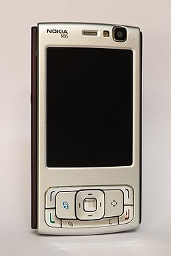
The Nokia N95 (N95-1, internally known as RM-159) is a smartphone produced by Nokia as part of their Nseries line of portable devices. The N95 runs Symbian OS v9.2, with a S60 3rd Edition user interface. The phone has a two-way sliding mechanism, which can be used to access either media playback buttons or a numeric keypad.
Its capabilities include: a Global Positioning System receiver with maps and optional turn-by-turn directions; a 5 megapixel digital camera with Carl Zeiss optics, flash, video recording and video conferencing; wireless connectivity via HSDPA, IrDA, 802.11x and Bluetooth; a portable media player with the ability to download podcasts over the air; a FM Radio tuner; Composite Video output via included cable; multi-tasking to allow several applications to run simultaneously; a web browser with support for HTML, JavaScript and Adobe Flash; messaging via SMS, MMS and e-mail; Office suite and organizer functions; and the ability to install and run third party Java or Symbian mobile applications.
Since the introduction of the original N95-1, several updated versions have been released as well: The N95 8GB with 8 gigabytes of internal storage and a larger display, the N95 NAM and the N95 8GB NAM with support for North American UMTS (3G) bands, and finally the lower cost N95-5 and N95-6 for the Chinese market.
Bank of England


Main article: Bank of England note issues
In 1921 the Bank of England gained a legal monopoly on the issue of banknotes in England and Wales, a process that started with the Bank Charter Act of 1844 when the ability of other banks to issue notes was restricted.
The bank issued its first banknotes in 1694, although before 1745 they were written for irregular amounts, rather than predefined multiples of a pound. It tended to be times of war, which put inflationary pressure on the British economy, that led to greater note issue. In 1759, during the Seven Years' War, when the lowest-value note issued by the Bank was £20, a £10 note was issued for the first time. In 1793, during the war with revolutionary France, the Bank issued the first £5 note. Four years later, £1 and £2 notes appeared, although not on a permanent basis. Notes did not become entirely machine-printed and payable to the bearer until 1855.
At the start of the First World War, the government issued £1 and 10-shilling Treasury notes to supplant the sovereign and half-sovereign gold coins. The first coloured banknotes were issued in 1928, and were also the first notes to be printed on both sides. The Second World War saw a reversal in the trend of warfare creating more notes when, in order to combat forgery, higher denomination notes (at the time as high as £1,000) were removed from circulation.
All Bank of England notes issued since Series C in 1960 depict Queen Elizabeth II on the obverse side, in full view facing left; her image also appears as a hidden watermark, facing right; recent issues have the EURion constellation around.
The custom of depicting historical figures on the reverse began with William Shakespeare in Series D in 1970. Since then, many other figures have featured on successive issues.
United Kingdom pounds sterling
| |||||
| ISO 4217 Code | GBP | ||||
| User(s) | |||||
| Subunit | |||||
| 1/100 | penny | ||||
| Symbol | £ | ||||
| penny | p | ||||
| Banknotes | |||||
| Freq. used | £5, £10, £20, £50 | ||||
| Rarely used | £1 (Scot., Jersey, Guernsey, IoM only), £100 (Scot. & N. Ireland only) higher values exist such as £100,000,000 (Titan) bank note, however, usage is restricted | ||||
| Central bank | Bank of England | ||||
| Website | www.bankofengland.co.uk | ||||
| Printer | Issuing banks: English (inc.Wales) notes:
Scottish notes:
Northern Irish notes:
Crown dependencies:
Note printer:
| ||||


Sterling banknotes are the banknotes in circulation in the British Islands (encompassing the United Kingdom and the British Crown dependencies), denominated in pounds sterling (symbol: £; ISO 4217 currency code GBP). One pound is equivalent to 100 pence.
The pound is the official currency of the United Kingdom and the Crown dependencies of Britain. Three British Overseas Territories also have currencies called pounds which are at par with the pound sterling.
In most countries of the world the issue of banknotes is handled exclusively by a single central bank or government, but in the United Kingdom seven retail banks have the right to print their own banknotes in addition to the Bank of England; Sterling banknote issue is thus not automatically tied in with one national identity or the activity of the state. The arrangements in the UK are unusual but not unique, as a comparable system is used in Hong Kong, where three banks issue their own banknotes in addition to the Hong Kong government.
Subscribe to:
Posts (Atom)